Eds. note: This archival article from Gene Stevenson’s Hot Water column was originally published in the Echo in September 1994. See the digitized version of the original here, complete with mysterious stains. At the time of republishing in February 2022, Lake Powell is at a historic low: 169 feet below full pool. If it drops 6 more feet, it will reach the threshold where hydropower is set to cease at Glen Canyon Dam.
PAIUTE FALLS – LAKE POWELL, UTAH
by Gene Stevenson and Don Baars
(revised from an earlier version printed in The Confluence, vol. 1, Winter, 1994)
Lake Powell, located in southeastern Utah, drowns a portion of the Colorado River and the lower segment of the San Juan River. And, yes, you read it correctly – there is a major waterfall on the lower San Juan River below the Clay Hills BLM boatramp. While the waterfall has been widely publicized by river-runners, most everyone else has either ignored its presence, or still assumes that the San Juan flows quietly unimpeded into Lake Powell. Nothing could be farther from the truth!
Certainly, one big reason to not publicize a waterfall on Lake Powell is that it is clear proof of man and bureaucracy’s failed attempts to control nature. The roar of Paiute Falls speaks loudly and clearly to those who will listen about an ecosystem that is endangered by man’s quest for dominion. Besides creating ecological nightmares, the damming of the high-gradient, silt-laden rivers in the Southwest has been called a “mistake waiting to happen.” And Paiute Falls is just the tip of the iceberg.

Around the world, waterfalls are usually highly regarded scenic masterpieces of nature, and what could be more appropriate than to include a year-round waterfall on beautiful Lake Powell? This marvelous lake is the result of the construction of the engineering masterpiece known as Glen Canyon Dam, built in the early 1960s to control the Colorado River, to help alleviate flooding downstream, to provide the much-needed hydroelectric power for such metropolitan cities as Phoenix and Los Angeles, and to provide unexcelled recreational opportunities for the masses who would otherwise be deprived of the joys of spectacular Glen Canyon in its natural state. To heighten the recreational facility of the project, an access was provided for powerboats to cruise under the previously seldom-seen Rainbow Bridge, and a little-known engineering marvel was recently added to provide a waterfall for our viewing pleasure.
As the population and development of agriculture mushroomed in southern California and southern Arizona, government survey expeditions were launched in the 1920s in the search for potential damsites along the mighty Colorado and its major tributaries so that the raging river could be “tamed” and the water impounded for “better use.” The Green and Colorado rivers were surveyed in 1922 in association with a San Juan River survey the same year—the Marble and Grand Canyon survey followed in 1923. The first dam—Hoover Hoover Dam—was completed the next decade in Black Canyon near Las Vegas, Nevada. Someone soon noticed that Lake Mead, the resulting reservoir, was rapidly filling with silt and sand carried down in copious amounts from the Colorado River drainage basin above. In spite of the well-advertised reasons for the necessity of a second dam upstream, Glen Canyon Dam would be required to halt the influx of sediments and the consequent early demise of the Hoover Dam engineering marvel. That is exactly when the “planning” process reached its zenith. Certainly, a second dam, if constructed upstream in time, would mitigate the problem, and besides, who would ever miss the remote, narrow, rock-barren Glen Canyon?
“The canyon no one knew” began to be engulfed in 1963, its archaeological and scenic treasures drowned forever. It took only two decades and two back-to-back winters of record snowfall in the Rocky Mountains to fill Lake Powell behind Glen Canyon Dam to its maximum elevation of 3,711 feet above sea level (asl), a level attained only in 1984. The result was that Glen Canyon Dam overflowed and the spillways were nearly destroyed. Quiet lake water lapped at the foot of Big Drop Rapid in Cataract Canyon on the Colorado, and Grand Gulch Rapid on the San Juan River was inundated. Hundreds of miles of drowned river canyons now clearly demonstrated the success of recreational fulfillment by hoards of powerboaters and water-skiers in the otherwise inaccessible canyons. The unadvertised real reason for building the dam – the cessation of sedimentary infill of Lake Mead – had also been successfully achieved. Or had it?
Where would all those cubic miles of sediments carried down from the eroding Rocky Mountains and Colorado Plateau come to rest? Once again, Glen Canyon Dam and Lake Powell came to the rescue. And besides, who would notice? The far reaches of the former Glen Canyon were in such desolate and fully isolated canyons that it mattered little as to their demise. The reservoir was so long, hundreds of miles long, that the lake bed would never be filled with silt; never become vast cornfields for the benefit of local Indian tribes; never crowd the storage capacity of such a marvelous engineering dynamo.
Unexpectedly, even to the water-hungry masterminds of the first half of the twentieth century, river-running came into vogue. Then people, by the tens-of-thousands, began floating the rivers of the American West. Throngs of river-runners invaded the canyons like locusts. They noticed! They saw flat water, teaming with water-skiers and houseboats, where wild rivers had once been. They fought the tortuous meandering channelways through mudflats where some of the most exciting rapids had been feared and recorded by the early explorers. They yearned for the marvelous spiritual experiences of Glen Canyon enjoyed by John Wesley Powell in 1869 and brought to life by the other fortunate few people, like the photo essay by Elliott Porter. They cursed the mud-drenched canyons and quagmires where boats must be retrieved at journeys’ end. They were not sympathetic with “the great recreational facilities” provided by the dambuilders.
The San Juan River
The headwaters of the San Juan River lie in the high San Juan Mountains of southwestern Colorado, near Wolf Creek Pass. Water from the upper basin and several tributaries are temporarily stored in Navajo Reservoir, located on the Colorado – New Mexico border. From Navajo Dam, the San Juan River flows unimpeded across northwestern New Mexico and into southeastern Utah where it finally converges with the Colorado River near the Arizona border in what is now Lake Powell.
On its course below Navajo Dam, the San Juan picks up and carries enormous amounts of suspended and bottom-load sediments. For its size, the San Juan carries comparatively more sediment than any other major tributary to the Colorado River. The source of most of these sediments is from the overgrazed plateau lands of the Four Corners Region. Spring runoff and late summer rains can rapidly change the San Juan from a docile stream to a seething torrent of mud. Throughout its course below Navajo Dam, then Juan River drops an average of more than 5 feet per mile, and as much as 14 feet per mile in the lower canyons. Historically, flows vary dramatically, from a recorded high of 91,000 cubic feet per second (cfs) in 1911, to several occasions when it basically dried-up. Since the construction of Navajo Dam in the early 1960s, the highest flow has been 25,000 cfs in 1970; the last decade has seen flows ranging between 15,000 cfs and 150 cfs.
Today, the San Juan River is popular for nearly 13,000 combined commercial and private recreational boating enthusiasts, annually. The most scenic stretch of river is from Bluff to Clay Hills Crossing, a distance of nearly 84 river miles. A few miles west of Bluff, the river leaves its lazy meandering course and flows through deep limestone canyons incised into the Monument Upwarp. It is there, on the west flank of the Monument Upwarp, that the high gradient, silt-laden river enters the placid waters of Lake Powell. And not surprisingly, it is there where nature is at odds with the “achievements” of man.

History of the Lower San Juan River Siltation Rate
The decision to build another dam above Lake Mead was based, primarily, on the tremendous rate at which this reservoir was silting-in. After exhaustive political efforts had failed to permit construction of dams in Grand and Marble canyons, the U.S. Bureau of Reclamation constructed Glen Canyon Dam near the Utah – Arizona border. Lake Powell began to fill in 1963 and power generation began in 1964. By 1980 the lake had filled to a sufficient height to finally test the spillways for the first time. The miscalculation (and overall lack of judgement) of the Spring runoff of 1984 nearly wiped out the dam, but, it held and the lake level was maintained at an average high reservoir pool elevation of 3700 feet asl until the summer of 1988.
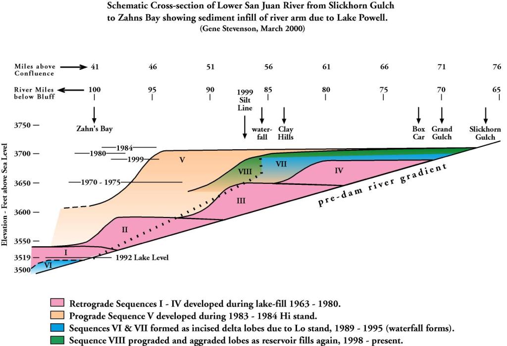
Moderate to dry winters over the past six years, accompanied with downstream demand, resulted in a low point of 3519 feet asl in mid-1992 (aerial observation of lake level at RM 100.2). This years high point came in June at nearly 3668 feet asl. This fluctuation in lake level of 192 feet over the past 10 years has certainly left its mark on the upper reaches of the San Juan arm of Lake Powell by, first completely filling it with a wedge of silt, then exposing vast “cornfields” of silt and re-routing of the San Juan River.
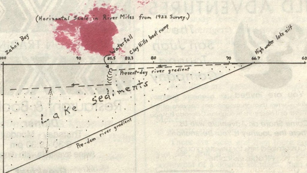
Just below Slickhorn Gulch (at river mile 66.7) is the first indication of lake-induced silt bars, marking the high water level of 3711 feet asl of 1984. For the next 16.6 miles to Clay Hills, the river now drops at a rate of only 0.42 feet per mile where it used to flow naturally at nearly 5 feet per mile. Even though the highest lake level in recent years is some 32 feet lower than the boat ramp at Clay Hills, this section of the San Juan maintains this sluggish meandering rate. Common sense and a little arithmetic should tell us that this section should have, by now, re-established its old gradient as the lake level dropped nearly 200 feet! Afterall, uncompacted layers of silt and clay are all that has filled-in the 85 feet of lost gradient. What is holding back all the silt?
Enter Waterfall
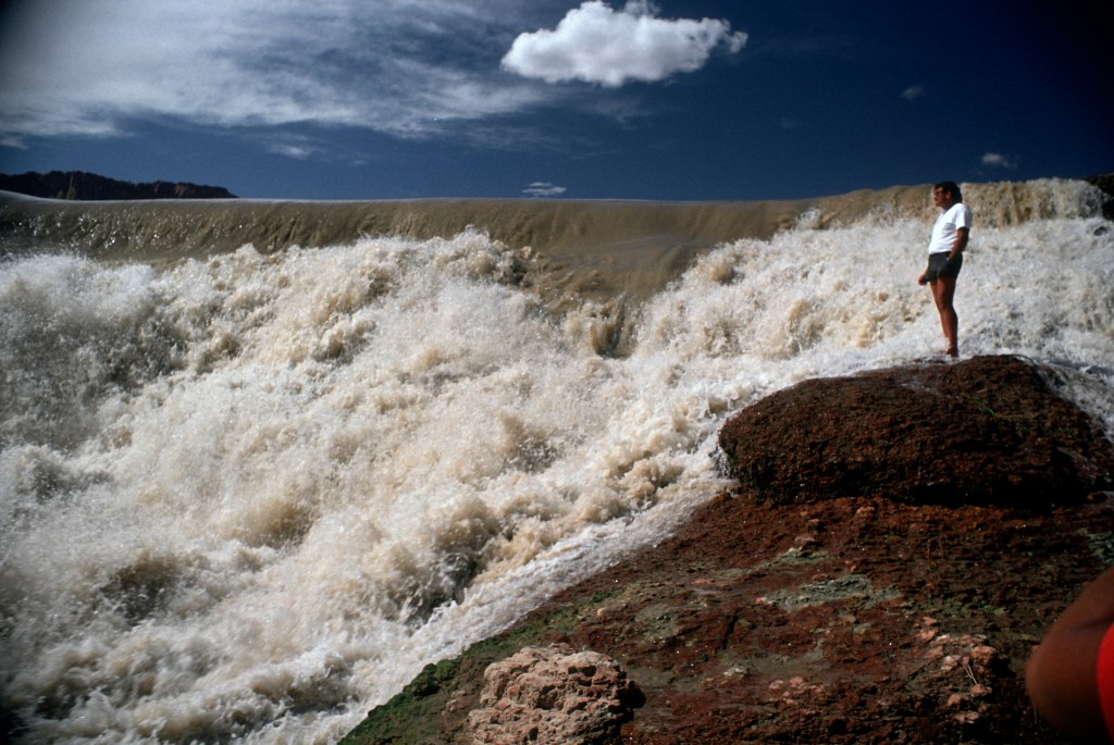
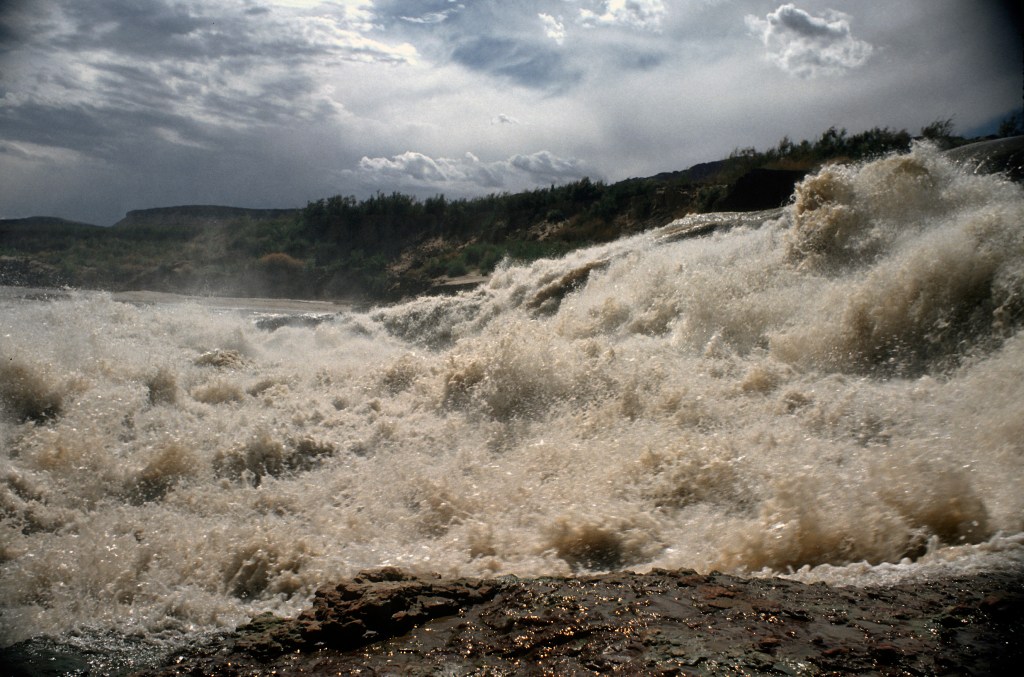
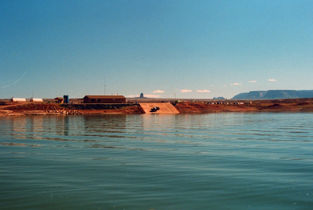
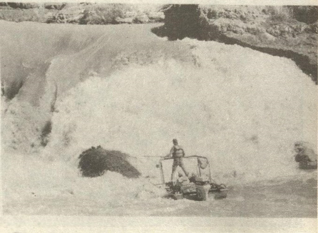
A waterfall now blocks navigation 2.2 miles below Clay Hills; the top of the falls is only 9 feet lower than high lake level (3711′) and the base of the waterfall is some 26 to 30 feet lower. The original course of the river flowed around a low-relief ledge of red rock (Organ Rock Shale of Permian age) along the right-hand (north) valley wall, and headed almost directly southward toward Paiute Farms, which at the time served as a Navajo-operated marina for upper Lake Powell and as a take-out point for many San Juan trips.
At high lake levels, silt was deposited evenly across the area and extended nearly 19 miles upstream to Slickhorn Gulch. The high-gradient, silt-laden river was forced to give up its suspended and bottom-load sediments to the artificially calm waters of the lake. During this highstand, all low-relief topography less than 3711 feet asl was buried by lake silt, creating a rather uniform profile of the lake bottom. As the river’s gradient was reduced by the silting-in process, the river’s energy slowed dramatically such that the sluggish and aimless meandering currents lost their way across the man-made delta, dividing into numerous distributary channels only inches deep.
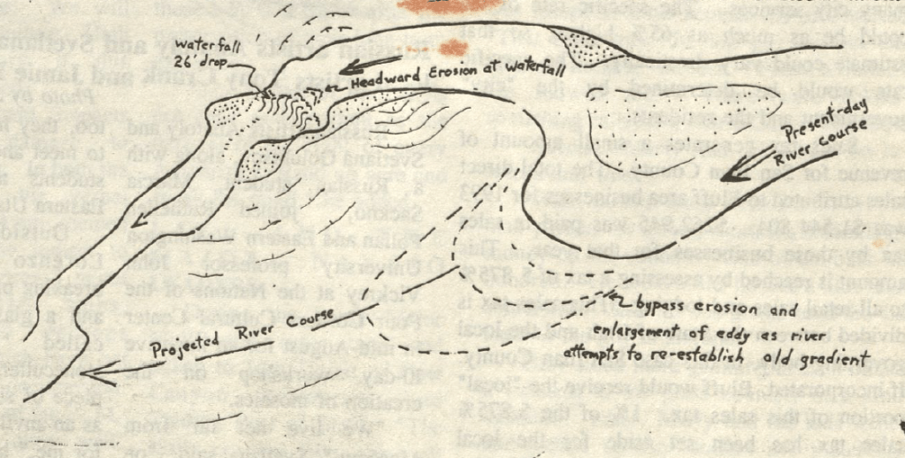
As the lake level began to lower in 1988, the river currents shifted slightly to the north to circumnavigate the delta, flowing across the buried red rock cliffs. The river current became trapped in the lake silt as the lake level continued to drop, and cut downward to the buried bedrock, forming a “surprise” rapid by year’s end. By late 1990, the rapid had become a formidable obstacle, such that no one but the foolish attempted running it. With continued lowering of Lake Powell, the rapid matured into a sheer waterfall that has become a curiosity to many, and an embarrassment to the dambuilders and lake enthusiasts. Fish studies currently ongoing by the U.S. Dept of Fish and Game are adversely affected by this new impediment to fish migration.
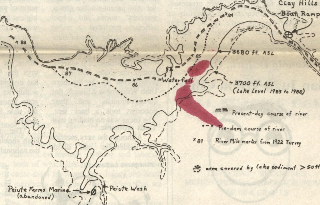
Trapped in the new channel, astride the exhumed rock ledge, the waterfall now forms a temporary nick point, or perched base level of erosion. Lake sediments trapped in the 19 miles of canyon above the waterfall have been temporarily suspended in the system at a level that ranges annually some 25 to 50 feet above the present-day base level of Lake Powell. The seasonal fluctuation combined with the overall lowering of the lake has accelerated the formation of yet another delta complex downstream of that held up by Paiute Falls. As of this writing, nearly 40 miles of the San Juan River corridor has been silted-in and the progradation toward the dam continues unabated.
In June 1992, the river flowed in a nearly straight path toward the waterfall, and by October a huge eddy had developed above the falls. The latest trip to Paiute Falls (Summer, 1994) shows the upstream eddy to be enormous, extending well south of the perched obstacle. The San Juan River is ever so slowly, but methodically, trying to re-establish its old course. Water is still flowing over the rock ledge, but now two small riffles have developed immediately upstream, signifying the future for this short-term attraction. You see, whether the waterfall is breached by erosion or the river finds a new course around the obstacle, one thing is certain, and predictable – the river will quickly re-establish its gradient and erode through the unconsolidated lake sediments that are deposited upstream. This geological process is known as “headward erosion” and, in this case, will be noticed by any observer by the loud “unzipping” sound.
Once the waterfall is breached or bypassed, the lake silts deposited above the falls will be quickly incised, leaving the newly expanded boat ramp at Clay Hills perched precariously above slumping walls of muck and mud. Unless the lake level returns miraculously to its 1984 elevation, river-runners can expect to be handing equipment up sloughing ledges in excess of 25 feet in the near future. Besides just being messy, take-outs will be potentially treacherous as dried lake sediments re-saturate with water and once again become quicksand.
Conclusion
Even though siltation rate was a major factor in the construction of another dam upstream of Hoover Dam, when Glen Canyon Dam was built there was no apparent consideration given to the huge volume of silt that would be deposited at the lake – river interface on the Colorado and San Juan rivers. No consideration whatsoever was given to the sediment-starved beaches that would develop downstream in Marble and Grand canyons. Least studied were the marinas located at the upper reaches of the lake; those necessary for the recreational objectives of the project; those that would be progressively silted-out such that continuous abandonment would be the only viable solution. Obviously, no consideration was given to drastically altered stream courses, the safety hazards that would result, nor of major ecologic damage that must necessarily follow.
A Navajo friend once explained why the Bureau of Indian Affairs was so reluctant to recognize Native American problems and approve changes. “It all started when Yellow Hair (Custer) said: ‘Don’t do anything until I get back!'” Perhaps John Wesley Powell had a similar affect on his Bureau of Reclamation.
(End of article)
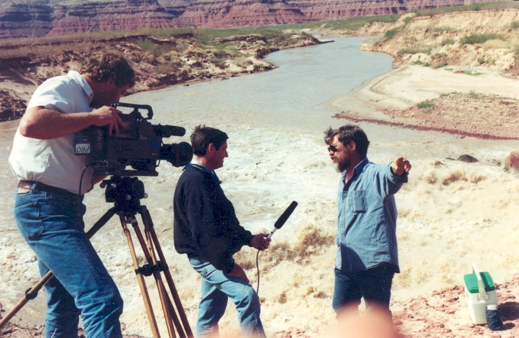
Additional photos provided by Gene Stevenson, with present-day commentary: