By Peter Winn

Carnotite (uranium and vanadium ore). Photo: Dakota Matrix
Uranium was used as a yellow dye in the first century by Romans and first identified as an element in 1789, identified as a metal in 1841 and the first radioactive element in 1896. It was originally called pitchblende, and Marie and Pierre Curie became famous for their studies of it in the early 1900s (she was the first woman to receive a Nobel Prize). She died of cancer from her exposure to radiation (primary radon, which she discovered in 1911), a term which she invented. Some of the samples she used in her research came from the Colorado Plateau. With an atomic number of 92 and atomic weight of 235 or 238, it is the heaviest of the naturally occurring elements. U235 is the isotope used in nuclear bombs and power plants, is only about 1% as common as U238 and is difficult to isolate.
Humans evolved less than three million years ago and Homo Sapiens less than three hundred thousands of years ago. The earliest written evidence of scientific thinking comes from the Sumerians about 5,000 years ago (before the Egyptians), who were among the first astronomers (they named the days of the week after the Sun, Moon and planets). The next major advance was in mathematics (the Greeks), then Galileo and Newton in the 1600s, then Darwin in the 1800s. Einstein “invented” relativity and his famous equation “energy equal mass times the speed of light squared” about a century ago, and the nuclear industry only began in the 1930s. The speed of light squared is a humongous number, which explains why a small nuclear bomb is so destructive. From this perspective, we humans are like toddlers playing with dynamite.
There are four types of radiation: alpha (a helium nucleus containing two protons and two neutrons), neutron, beta (an electron or positron) and gamma (a ray, but not a decay product). When U238 decays (called fission), it emits alpha radiation and the decay process stops at Pb206 (lead). The half-life (when half of the isotope has decayed to another element) of U238 is 4.5 billion years. Geologists use the ratio of U238 to Pb206 to determine the age of a rock. When U235 decays, it emits alpha radiation and the decay process stops at Pb207. The half-life of U235 is 700 million years. When a fission bomb explodes, most of the uranium is converted to lead within hours or days, so there is no significant permanent residual radioactive contamination, though there is a small increase in cancer rates. The main reason for the concept of Mutually Assured Destruction (MAD) that has kept Homo Sapiens from using nuclear weapons (so far) is the huge immediate death toll (up to two hundred thousand civilians) and the huge amount of physical destruction of Nagasaki and Hiroshima at the end of WWII. I grew up on military bases during the early years of the Cold War – we didn’t have fire drills in school – we had nuclear war drills, for what they were worth. On the other hand, the four square mile core zone of the Chernobyl nuclear power plant explosion in 1986 is likely to be uninhabitable for 20,000 years.
In the 1930s, a number of very talented physicists emigrated from Germany to the US, including Oppenheimer, Einstein and his math teacher, Kurt Godel. Einstein once said “God does not play dice” and Godel proved that mathematics is based on propositions that can’t be proved – they must be taken on faith. Einstein and Godel were opposed to the use of atomic bombs, so Oppenheimer led the group, but they assisted in their design, which were constructed using uranium partly sourced from the Four Corners area. This began a craze of exploration for uranium in this area after WWII (from mining claims located using the 1872 mining law, which is a total mess and should be replaced with a leasing program like that used for oil, gas and coal), spurred by the Atomic Energy Commission (AEC), which required all production to be sold to it, of course at an attractive price. Finding uranium easily became possible after the Geiger Counter, a portable tube that could measure gamma radiation, was invented in 1928 and became widely available by the 1940s.
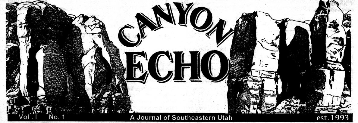
Circles represent uranium mines in southeastern Utah. Tan color represents the Chinle Formation (Triassic, about 250 million years old), blue color represents the Morrison Formation (Jurassic, about 100 mya). Uranium in the Chinle is concentrated in the basal Shinarump unit, and in the Morrison in the basal Salt Wash unit. Both are river sands or gravels and relatively porous and permeable. The Shinarump rivers drained westward from the Ancestral Rockies. The Morrison rivers drained east from the Ancestral Sierra Nevada. The Morrison is famous for dinosaur fossils, and the Jurassic is famous for Jurassic Park, a movie where a Tyrannosaurus Rex eats an attorney hiding in an outhouse. Map: Utah Geological Survey
Most of the roads in this area, including Bears Ears, were dozed by uranium prospectors. The Chinle is exposed on the lower slopes of the Bears Ears and hosts the fossilized trees in Petrified National Forest in Arizona. The Shinarump caps the towers in Monument Valley and there is a great exposure at the Lees Ferry, AZ boat ramp where Grand Canyon river trips begin. The Salt Wash unit hosts uranium mineralization in the Uravan area and the full thickness of the Morrison underlies White Mesa.
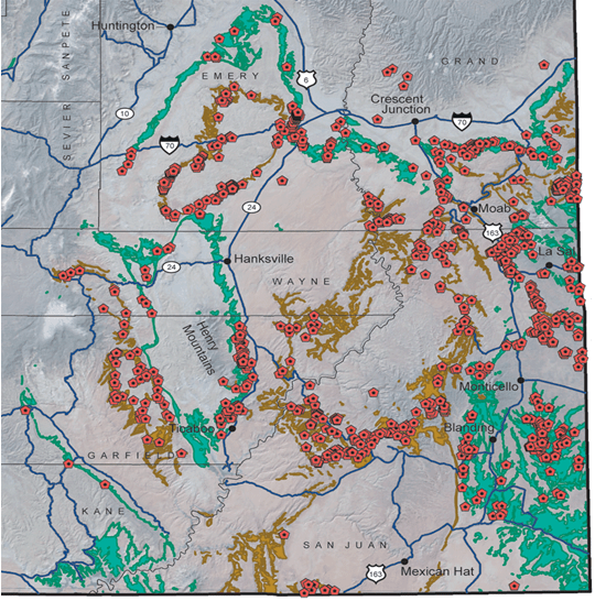
There are a dozen different types of uranium deposits, but the “roll front” is most common on the Colorado Plateau. Uranium leaches into ancient river sands and concentrates where it is “reduced” by carbonaceous material. Uranium was originally dispersed in the volcanic ash of the Chinle and Morrison and migrated to the basal units as the ash degraded to clay over tens of millions of years. Roll front deposits are typically moderate to low grade, not very thick or extensive, and almost always require expensive underground mining. They were a primary source of uranium in the 1950s-1960s, accounting for about half of the uranium purchased by the AEC. The other half came from volcanic hosted deposits associated with the Rio Grande Rift on the Navajo Reservation north of Grants, NM and the Apache Reservation east of there. When the nuclear power industry expanded in the 1970s and the AEC stopped buying high price uranium from these deposits, large low-cost open pit mineable deposits were discovered in Canada and Australia, which are US allies, and the price dropped too low for mines in the Four Corners area. Image: History, Geochemistry and Environmental Impacts of Contaminants Released by Uranium Mining in South Texas, by Ronald Parker and Bruce Herbert
Conventional uranium mills use several toxic chemicals to dissolve uranium from ore ground in water, which end up in their tailings (waste). The typical grades of uranium ore range from 0.1% to 1%, so the volume of tailings is very large. The typical mill has an extraction rate of 90%, so tailings are typically 0.01% to 0.1%. uranium.
Like fossil fuel power plants, nuclear power plants rely on heat energy to boil water to produce steam to drive a turbine to produce electricity, while mechanical energy is used to drive turbines for hydropower and wind power and solar energy converts sunlight directly into electricity. As we know, fossil fuels cause air pollution (including CO2), but both fossil fuel and nuclear power plants also produce a lot of heat that is lost to the atmosphere (the cooling tower), as do vehicles, ships and airplanes when they burn fossil fuels. Homo Sapiens also heat the atmosphere – our internal temp is about 99F, but skin temp is low 70s, a 25% loss of body heat.
Nuclear power plants are also very inefficient: less than 10% of the uranium in a nuclear fuel rod is used to produce electricity. The rest is either recycled (such as in France) or stored as high-grade waste (such as in the US). The costs associated with storage are largely borne by the entire tax paying population, not just the power plant customers. This is a huge subsidy, though all energy sources in the US are partially subsidized and it’s impossible to determine the relative amounts. So far, the US government hasn’t established a high-grade waste site, but it has moved millions of tons of low-grade tailings (waste) to sites where leakage is not likely to result in river or groundwater contamination. The tailings from regional uranium mills have been removed from in town to out of town sites in the Mancos (Moab and Grand Junction) or Morrison (Monticello) shales, which have very low permeability and porosity. In the 1960s, tailings were sometimes used by citizens of these towns as grog in cement. This was largely removed in the 1980s remediation programs.
Dennison Mines, a Canadian company (with mostly US shareholders and Canadian staff) that began operations in Ontario in 1954, was acquired by International Uranium Corp. in 2006. In 2012, it divested its US properties to Energy Fuels Resources (now Energy Fuels Inc. (EFI), NYSE: UUUU), a Canadian company with mostly US shareholders and US staff), which included the White Mountain mill and several local mines in San Juan County UT, Coconino County AZ and Montrose County CO, in return for stock. Its website is https://www.energyfuels.com/.
Dennison’s stockholders also received some EFI stock, including Korean Electric Power Corporation, which has a contract to purchase 20% of Denison’s (and thus EFI’s) uranium production. In 2012, the mill was about 30 years old, near the end of its productive life, and uranium prices had recently risen so EFI applied for permits to build the Pinon Ridge Uranium Mill between Naturita and Bedrock in Montrose County, Colorado and to reopen mines in this area. As an experienced economic geologist (and just retired), I was invited by the Western Colorado Congress to evaluate the project and make a presentation to them that included the Montrose County Commissioners. I concluded that the project was not economic based on the rapid growth in uranium supply from low-cost open pit mines in Canada and Australia (allies of the US), which would depress prices below the project’s break-even point. Although the permit was issued, the mill was never built, and EFI sold its interests to Baobab Asset Management in 2015.
The closure of the mill in Monticello and the mills and mines in the Uravan, Naturita and Nucla area caused a significant depression and ultimately an increase in cancer rates. Read “The Price of Nuclear Power: Uranium Communities and Environmental Justice” by Stephanie Miller (2015) for details. Uravan is now a museum. White Mesa is currently the only mill in the US that is licensed for processing radioactive materials and has become quite controversial. See the Grand Canyon Trust article at https://storymaps.arcgis.com/collections/de5bb7d9fa904e1591e605f485f1f675?item=1 for details.

Page 28 of “Assessment of Potential Migration of Radionuclides and Trace Elements from the White Mesa Uranium Mill to the Ute Mountain Ute Reservation and Surrounding Areas, Southeastern Utah,” by USGS, EPA and Ute Mountain Tribe (2011). Note unit thickness is in meters. This cross section is typical of the Colorado Plateau, though here the Bluff Sandstone is between the Morrison and Summerville, and the Summerville is called Wanekah. It forms the red slope below the Bluff Sandstone and the Entrada is covered by San Juan river gravels on the valley floor below the town. If there is uranium in the Salt Wash Member, it has not leached through the Waneka clays into the Navajo aquifer.
The White Mesa Uranium Mill is located about a thousand feet above the Navajo Sandstone, the aquifer that both Bluff and the community of White Mesa tap for drinking water. The upper hundred and fifty feet are relatively porous and monitor wells indicate the presence of uranium and other hazardous contamination, indicating the plastic liner under the mill’s tailings ponds is leaking. This is not at all surprising – we all know plastic degrades in sunlight, and should expect it to degrade when bombarded with gamma rays. Fortunately, there are about eight hundred feet of Morrison and Summerville clays above the Navajo, which should provide at least a thousand years of protection. Thick clay layers have very low porosity and permeability, plus wet clays are self-sealing if fractured. Also, a significant percentage of the sedimentary rocks present in the Bluff area represent windblown sands, including the Cedar Mesa Sandstone (the de Chelly Sandstone that makes the towers in Monument Valley is probably marine), the Wingate Sandstone that caps Comb Ridge, the Navajo Sandstone (white cliffs in Zion National Park), the Bluff Sandstone and the Entrada Sandstone (hosts the arches in Arches National Park). The recharge area for the Navajo aquifer is where it outcrops on the south flank of the Abajo Mountains. The recent high winds suggest that Bluff may blow away before our drinking water is contaminated by White Mesa mill tailings.
The really big problems are the rapid growth of the human population and the rapid growth of the consuming class. The population has increased from about a billion at the beginning of the industrial revolution two centuries ago to over seven billion today and is projected to reach ten billion by the end of this century. Plus, the percentage of the population that buys houses, cars, phones, computers and hundreds of other products that are often made using toxic materials is rapidly increasing, as is the waste, including radioactive waste, created by mining and drilling, producing energy to live and travel, and so is war and violence, and the potential for pandemics, etc, etc. In the long term, the best way to minimize the need for messy sites like White Mesa’s mill is to reverse this growth.
