Stewart Aitchison
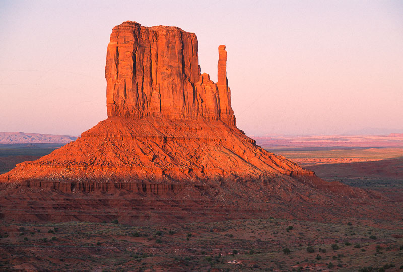
Photo: Stewart Aitchison
“The monuments are barrels or Navajo water baskets, and the springs found at their bases is proof. Rain God Mesa and Thunderbird Mesa are the homes of thunder and lightning. The entire Monument Valley is a symbolic hogan. Its fireplace is the butte near Goulding’s Trading Post and its door faces east near the Monument Valley Navajo Tribal Park Visitor Center. The doorposts are Gray Whiskers Mesa and Sentinel Mesa.”
-Navajo Tradition
As my traveling companions and I came around Thunderbird Mesa, an angry-looking grayish-purple sky came into view, casting an ominous backdrop to the reddish-orange monuments. Nearly constant streaks of lightning flashed from cloud to cloud and cloud to ground. Peals of thunder echoed across the valley. It was the violent type of storm the Diné call male rains.
A few quick pictures of the Totem Pole and the Yei Bi Chei were all we had time for before a blast of wind sent a cloud of gritty sand flying our way. Before we all were back in the four-wheel-drive van, sheets of rain engulfed us.
Within a few minutes, small ribbons of water were streaming off Spearhead Mesa and Rain God Mesa. Red rivulets raced us as we drove past Camel Butte. By the time we reached Stagecoach Wash, a torrent of mud and water was filling the channel. We drove across the wash cautiously, for the power of water is truly amazing. Paradoxically, in this land of little rain, flashfloods can be sudden and devastating. A particular storm may drop less than an inch of precipitation, but the general lack of vegetation and soil prevents the water from being absorbed. Instead, the rain runs off the exposed rock surfaces and quickly collects into bigger and bigger drainage systems, or washes, until a wall of churning water, mud, and debris scours out a section of the desert. The steeper the gradient, the greater (by a geometric progression) the carrying capacity of the moving water; hence, floods in short, steep canyons can be much more powerful than in larger, open, relatively flat valleys.
It is the power of water – whether as dramatic flooding, or the slow corrosive action of dissolving the calcium carbonate cement bonding grains of sand, or the subtle action of expanding ice forming in cracks to wedge rock apart – that has been the sculpting force in the creation of the Southwest landscape.
According to geologist and guide Gene Foushee, there must be three conditions fulfilled in order for a “monument valley” to form. First, there must be a massive layer of hard rock overlying a massive layer of softer rock. In Monument Valley the thick, relatively hard DeChelly Sandstone sits on top of the softer claystone known as the Organ Rock Tongue. Second, these two layers must be in a relatively horizontal attitude. To the east and south of the valley, the DeChelly and Organ Rock (along with several other layers) are tilted to form the striking escarpment of Comb Ridge instead of the classic monument. Third, these rock units must be in a dry climate. Put these same rocks in a humid, temperate zone and they would be rounded off and quickly (geologically speaking) covered with soil and plants.
Once the three prerequisites are met, all that is needed is time – incomprehensible amounts of time. But nature has all she needs. Rains come and, at random, flow across the almost flat surface of the DeChelly Sandstone. Some of the water follows incipient cracks in the rock surface; cracks perhaps caused by stress related to the uplift of the Four Corners region as well as additional uplift within Monument Valley that has been going on for the last 60 to 70 million years. These cracks or joints are essentially vertical planes of weakness and are widened by the power of water. As this process continues, eventually the vast, horizontal bed of sandstone is divided into smaller pieces with vertical sides. The hardness of the rock tends to preserve the precipitous sides of the forming mesa. Once the downward-cutting channels encounter the softer Organ Rock Tongue Claystone, undercutting can take place and slabs of the unsupported DeChelly Sandstone spall off along additional existing joints. These broken blocks of sandstone along with the softer claystone form the slopes that encircle the base of the monument. Through time the larger mesas are reduced in size to buttes, all the while continuing to display the classic profile of a monument.
All the stages of monument development are wonderfully displayed in the valley, which of course is not a valley at all in the usual sense. And what will become of today’s monuments? They, too, will succumb to the forces of time and erosion, but Gene Foushee tells us not to worry: Future monument valleys will no doubt form where a massive sandstone overlies a massive claystone. “The extraordinary monuments are simply the children of the mesas.”

Photo: Stewart Aitchison
The origin of the landscape has been told, but what about the origin of the rock layers themselves? The oldest rock exposed in Monument Valley is Cedar Mesa Sandstone, which was laid down as sand in a shallow marine environment in early Permian time (the Permian Period lasted from 286 to 245 million years ago). The tourist road crosses the top of the Cedar Mesa Sandstone in a wash just after descending from the visitor center.
As time passed, the area became more of a wet tidal flat with streams and rivers flowing westerly and southwesterly from a massive mountain range, the Uncompahgre Range, several hundred miles to the northeast. The rivers carried heavy sediment loads of granitic and gneissic material and deposited them on the coastal lowlands. The boulders and larger pebbles settled out first, close to the mountains; the finer sand, clay, and silt were carried farther by the sluggish rivers and deposited as red beds six hundred to seven hundred feet thick, from the vicinity of Canyonlands National Park south through Monument Valley and west toward the Grand Canyon region.
At this time primitive amphibians and reptiles roamed the lowlands, and plant fossils indicate that the environment was arid. Geologists have named these red deposits the Organ Rock Tongue after an erosional feature that resembles a pipe organ west of Monument Valley.
By mid-Permian time, the sea attempted to encroach from the west but reached only a little east of where the Grand Canyon would one day form. From the shoreline eastward, a vast desert formed as hot, dry winds piled quartz sand into mountainous dunes hundreds of feet high, patterned with ripples. The individual fine sand grains are often coated with iron oxide giving a reddish orange cast to them. As more and more sediment was added to the deposit, the buried sand was slowly cemented together with silica and calcium carbonate “glue” into a three-hundred- to six-hundred-foot-thick sandstone called DeChelly.
Until the end of the Permian, the Monument Valley area remained a desert coastal lowland that was either gently eroding or with little or no additional sedimentation taking place. The Uncompahgre Mountains were nearly leveled, and the few meandering streams were virtually clear of sediment.
Through Triassic, Jurassic, and Cretaceous time (about 245 to 65 million years ago), as the region fluctuated between coastal mud flats, swamps, and deserts, other deposits of sedimentary rocks were added to the geologic layer cake. However, in Monument Valley, most of these thousands of feet of younger layers of rock have been stripped away over the last 65 million years as the Colorado Plateau (the geologist’s designation for the Four Corners region) has been uplifted a mile or more above sea level. A few of the mesas and monuments are still capped with remnants of the Moenkopi Formation and Shinarump Member of the Chinle Formation.
Whether you approach the Monument Valley area from the south or north on U.S. Highway 163, some of the first “monuments” you see are not the typical erosional remnants of reddish sedimentary rock, but rather are solitary towers of black rock that, according to Navajo lore, help hold up the sky. Alhambra Rock to the north and Agathla to the south are geologically volcanic necks, the solidified material that once filled a now-eroded vent possibly leading to a volcano. Some of these igneous features seem to have been created by the explosive energy of gas-charged magmas drilling through enclosing sedimentary rock.
Probably by the time of the Pleistocene Ice Age, Monument Valley was looking very much like what we see today, at least in terms of major topographic features. However, a closer examination of the past environment would reveal fewer deep washes and decidedly different plants and animals than today. Where there are now stands of blackbrush, during the Pleistocene, there were woodlands of pinyon pine and juniper. Where the pinyon-juniper woodlands now grow probably would have been Douglas fir forests. Ice Age temperatures were considerably cooler than today’s climate, and there were more permanent streams and springs. Near the formation called the Totem Pole, what is now just sandy desert were small freshwater ponds teeming with minute snails and other freshwater invertebrates.
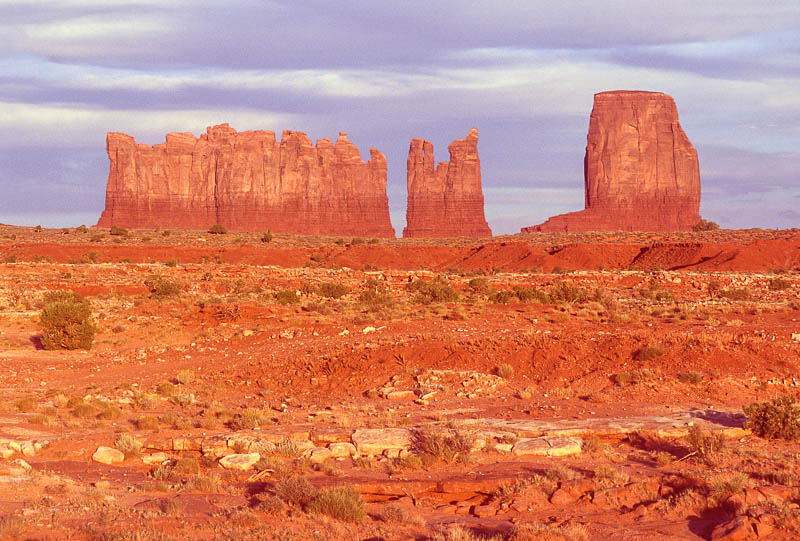
Photo: Stewart Aitchison
During the last two million years, the Monument Valley area was apparently subjected to alternating periods of sand and clay sedimentation and erosion. Evidence suggests that at the end of the Pleistocene, about ten thousand years ago, the climate was more humid and cooler than it is at present. This was a time of more deposition than erosion; of mammoth herds; and probably of the first human hunters.
The cyclic nature of climatic change continued. Dry desert winds blew sand into great dunes during an erosional phase. After a few thousand years, a moister and cooler climate returned. Streams flowed through the valley creating small lakes and depositing sediments. Artifacts of the early Ancestral Puebloans date from this time (100 B.C. to A.D. 700). Then a drier climate and arroyo-cutting returned, ending about the time the Ancestral Puebloans left Monument Valley (A.D. 1250). (These harsher growing conditions probably stimulated the Ancestral Puebloans departure from the valley.) This was followed by yet another period when deposition gained over erosion, lasting from A.D. 1300 to 1700 and accompanied by warm and dry weather.
By the 1880s, the continued drying of the climate and increasing numbers of livestock initiated the present state of erosion. Nearly all the deep arroyos and washes cut into the soft sandy sediments seen today around Monument Valley have formed in the last hundred years. Sand derived from eroding DeChelly cliffs is washed down arroyos, the water evaporates, and southwesterly winds pile the fine sand into huge dunes against the mesas.
The Monument Valley landscape of today is thus an interplay of geologic and climatic forces with some finishing touches added by human activity. In 1937, two years before his death, local resident Hoskininni-begay summarized his perception of the present human condition in Monument Valley:
“Most of our people are poor now, like I am. Many of them blame John Collier [Commissioner of Indian Affairs], who made us reduce our flocks and herds because there was not enough grass for all. But I think the true reason is a change in the climate. When I was a young man this whole country was covered with tall grass. We had rains enough in summer to keep it alive and growing. Now the rains do not come and the grass dies. There are fewer sheep and horses now than when my family claimed this valley, yet all you can see is sand. The grass is gone. All we need to be rich again is rain.”
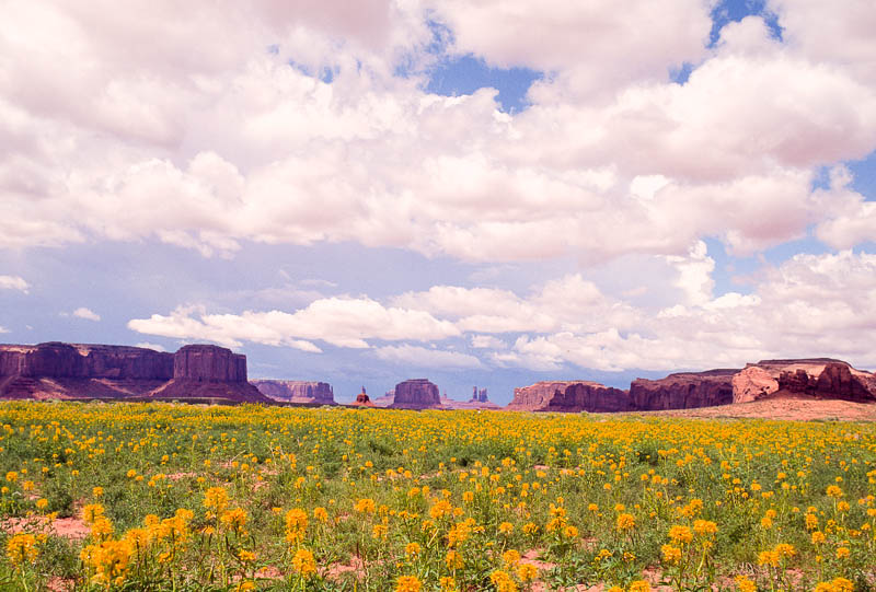
Photo: Stewart Aitchison
Stewart Aitchison is a former field biologist for the Museum of Northern Arizona and has been a naturalist/photographer/tour leader for several educational organizations. Through Gene Foushee, Stewart became friends with the Yazzie/Holiday family in Monument Valley, which led to writing A Traveler’s Guide to Monument Valley (MBI Publishing Company). Rock Tales is a chapter of the book, republished here with Stewart’s generous permission. His latest book is The Official Guide to Grand Canyon’s North Rim (Grand Canyon Conservancy).
