Peter Winn
A disclaimer: I’m a retired whitewater river guide and retired geologist. How do you tell if a river guide is telling a tall tale? He opens his mouth (it would be a mistake to say this is true for female guides). How do you tell if a geologist is telling the truth? Wait a century to see if other geologists still agree.
I started working as a river guide in 1967, first rafted the Grand Canyon in 1969, kayaked it in 1970 and first ran the San Juan in 1972. I’ve since run all of the main stream Colorado River and its major tributaries on the Colorado Plateau and hiked Escalante, Paria, Kanab and Havasu canyons. They all have deeply incised goosenecks, including the creeks that are too small to float. The only other region on our planet that is characterized by an abundance of them is the Tibetan Plateau. Both of these plateaus (they’re really basins) are also surrounded by glaciated mountains and both were (and are) subject to geologically rapid uplift.
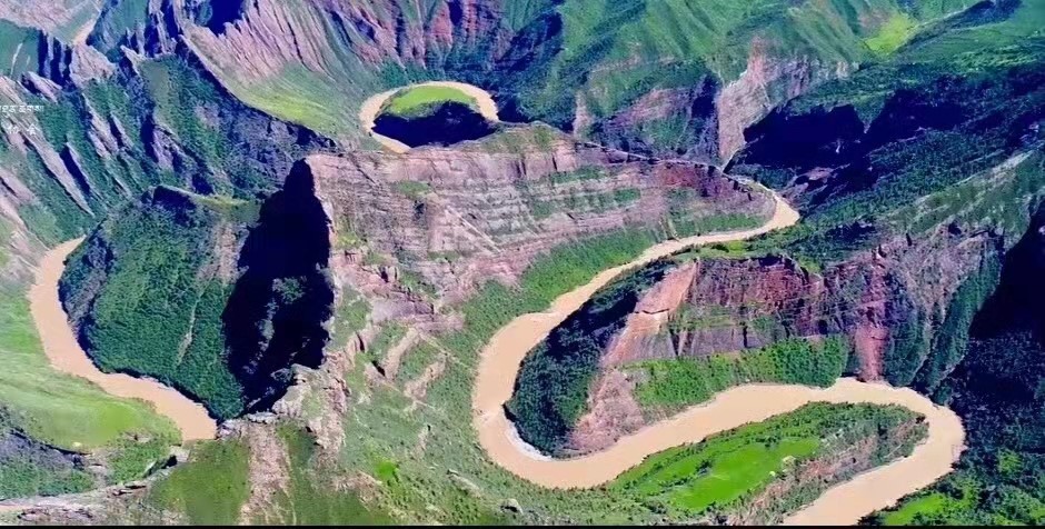
Deeply incised meanders of the Ji Qu, a major Mekong headwaters tributary on the Tibetan Plateau, now part of Three Rivers National Park. Photo by Yang Yong, a geologist on the 1986 first descent of the Yangtze, the 1987 first descent of the Yellow, the 1998 first descent of the Bramaputra headwaters in Tibet and paddle raft captain on a 2004 Chinese charter trip in the Grand Canyon. Yang is a good friend of my son Travis and participated in many of Travis’ commercial river expeditions on the headwaters of the Yangtze, Mekong and Salween in western China both on and off the Plateau.
I met George Simmons and David Gaskill on my first Grand trip in 1969. They had recently published a mile-by-mile geology guide to the Grand Canyon and were members of a Powell Society expedition celebrating the Powell Centennial. John Wesley Powell was a geologist, led the first descent of the Green and Colorado, was the second director the US Geological Survey, and Lake Powell is named after him. At the time, I was a computer science major and premed student, so their guidebook was Greek to me. A year later I met Bill Breed, the Curator of Geology at the Museum of Northern Arizona, on an MNA charter Grand trip. Bill had recently edited a book on the geology of Grand Canyon, and again I couldn’t read it. Bill convinced me to take a class on the geology of the Canyon, and my dad sent me to see a psychiatrist when I told him I’d changed my major.
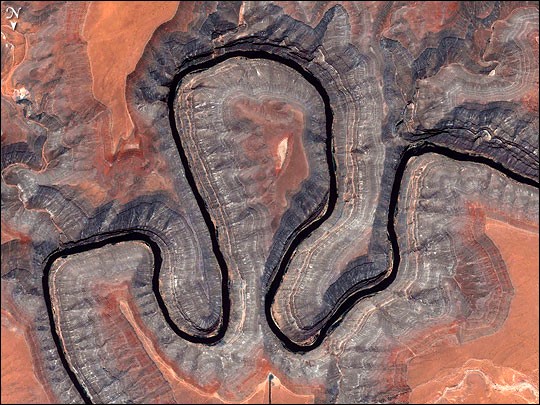
Nowadays, about fifteen thousand people float the San Juan annually, but fifty years ago not many people knew about it, except for Kenny Ross, a local river outfitter, musician Katie Lee who sang a song with a verse that said, “they tell you you’ll ride every riffle, don’t you believe it you’ll walk down the middle,” and a bunch of river-running geologists. These included Gene Foushee, who quit working as uranium exploration geologist for Union Carbide to build Recapture Lodge, and Don Barrs (Fort Lewis College), whom I met on the river. Gene Stevenson and Don later wrote a mile-by-mile geology guide to the San Juan (see image below, Gene also contributed a chapter on the San Juan Goosenecks to a book on the geology of Utah State Parks). I also boated with Gene Shoemaker (lots of Genes), who was one of the authors of the geologic map of the Mule Ear Diatreme (and co-discovered the Shoemaker-Levy Comet).
I eventually began to lead trips for groups of geologists, mostly from Flagstaff USGS, NAU and universities in the Four Corners states, which began to incorporate the San Juan in their geology field camps, both on the Colorado in Grand Canyon and on the San Juan. Gordon Swann, the chief geologist at USGS, sold his ski boat and bought a raft to run the San Juan (after being knocked off his water skis when lightning struck Lake Mary). His wife Jodie was the librarian for Moon and Planetary Photography at USGS, and Gordon had a moon rock in a sealed glass cylinder in his office. Will Downs was a world-famous paleontologist at NAU and a San Juan and Grand Canyon boater. He found the oldest mammal fossils on several continents.
Lowell Braxton, Director of the Utah Division of Oil, Gas and Minerals, also learned to row on the San Juan. He helped me carry Tom McCandless, a paraplegic diamond geochemist, up to the Mule Ear Diatreme to collect samples of garnets and zircons with microdiamonds from ant hills (diamonds are mined from diatremes in Canada, Wyoming and South Africa). Tom estimated the volcanic gases and magma originated about eighty miles below the surface, but thought it was unlikely the ants dug that deep. Of course, sometime during the next century a geologist from the Gaia Society may discover very slow-moving ants from the Earth’s mantle that are made of garnets laced with diamonds.
Bruce Babbitt, former governor of AZ, former US presidential candidate and former US Secretary of State, had a BS in geology and was a San Juan rafter before he got into politics (his family is from Flagstaff). We sometimes rented the entire Pioneer/Dekker house, which was owned by Recapture for many years, and Gene Foushee would give one of his famous geology slide shows on the evening before the river trip.
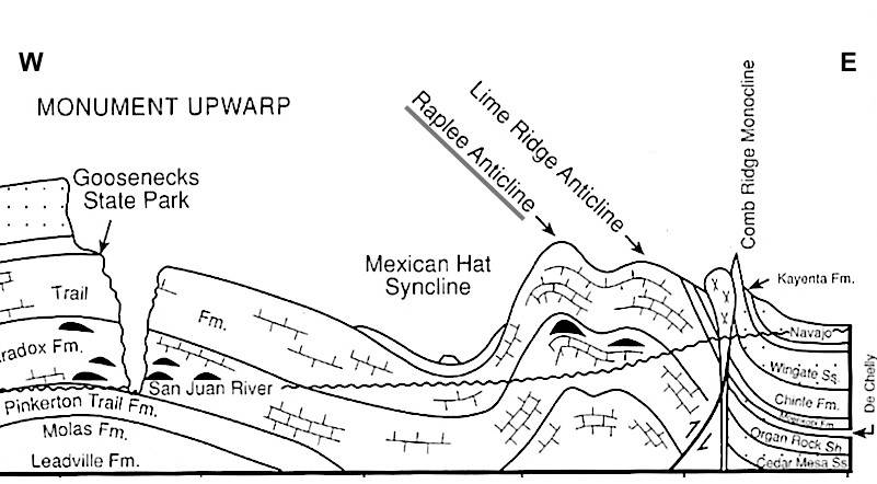
The Mule Ear, visible from the Bluff Cemetery, is the pinnacle on the east, and the nearby diatreme (a gaseous volcanic neck) is marked XXX. Both are really cool hikes with a great view of Monument Valley, Comb Ridge and Chinle Creek, but the scramble down from the Mule Ear can be spooky. The cliff on the west is the Cedar Mesa Sandstone, which underlies Cedar Mesa and the Leadville Fm. is equivalent in age to the famous Redwall Limestone in the Grand Canyon, formed by a 400 million year old sea. To the east of this cross section, the Navajo is the aquifer tapped for Bluff’s water supply and to the west of Cedar Mesa, it forms the cliffs of Glen Canyon (and Cathedral in the Desert and Rainbow Bridge) and the massive cliffs of Zion National Park. For an extensive discussion of the diatreme, see the last chapter of Gene’s book, Canyon Country Explorations & River Lore: The Remarkable Resilient Life of Kenny Ross, at the Bluff Library. According to Eirene Hamilton, Navajo call the Mule Ear either Tsé Łikizhí (Spotted Rock) or Tsé Naashch’ąą’í (Colored /Colorful Rock), Tsékooh Yilíní is Where the River Flows into the Rock Canyon below the diatreme and Ayi’nát’ání is the Perched Meanders (goosenecks).
The geology of the Grand Canyon is overwhelming, but being able to visit the Mule Ear Diatreme, float through the Lime Creek/Raplee Anticlines (and a couple of incised meanders) and only take a few days out of a busy schedule is a big draw – not to mention the stunning scenery, archaeology and the fact that it’s a perfect river for learning to raft and kayak.
There are nearly 350 deeply incised goosenecks in the Colorado River Drainage. They occur on every tributary down to Havasupai in western Grand Canyon. Besides the San Juan, the best known are Steamboat Rock at the confluence of the Yampa and Green in Dinosaur National Monument, The Loop on the Colorado in Canyonlands National Park below Deadhorse Point State Park, The Turks Head on the Green in Canyonlands, Horseshoe Bend on the Colorado in Glen Canyon downstream from the dam, and Hansborough Point in Marble Canyon above the Little Colorado confluence. All of them are located on the upstream side of 65-million-year-old major uplifts such as the Uncompahgre south of Grand Junction, the Monument in southeast Utah and the Kaibab in northeast Arizona, or on the upstream side of 25-million-year-old volcanic intrusions (laccoliths) such as the La Sal, Henry and Navajo mountains in southeast Utah. The general theory is that rivers draining the Sevier, Uinta, Rocky and San Juan Mountains (also about 65-million-years-old) ponded on the upstream side of these features and meandered over their own flood plains until they filled in the basins and flowed over the highlands, beginning to integrate into the modern drainage system. This integration was complete by about 6 million years ago, but there’s a lot more to the process of incision.
Shoemaker’s geologic map of the Mule Ear Diatreme shows large blocks of 75-million-year-old Mancos Shale that fell into the volcanic neck after its last explosion (see cross section below). This unit is visible in the Book Cliffs north of Grand Junction, but all rocks younger than about 200 million years have been eroded from the diatreme. Their presence in the diatreme means that about a mile of rock has been eroded from the San Juan goosenecks area.
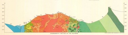
The pinnacle on the right is the Mule Ear (Wingate Sandstone). The green blocks on the left and upper right of the diatreme are Mancos Shale. Volcanic rock is red. Note that everything below the surface is mostly artistic license (geofiction).
Studies of the sediment in the Salton Sea and Sea of Cortez (Gulf of California) suggest that the Colorado River system eroded and transported it there. Until recently, there was a bit of dispute as to when this erosion occurred. An analysis of global delta sediments deposited by major rivers by Will Downs and Peter Molnar indicates that the volume of sediment deposited in deltas in the past four million years is greater than the volume deposited over the previous seventy-six million years. Molnar, a mountain climbing and river running geologist from MIT and major contributor to the theory that the Himalayas are a result of a collision between India and Asia, met Will on a San Juan trip and they later floated the Yangbi, a major tributary to the Mekong in southwest China, with me to study fault zones related to the collision. A study completed by my daughter Carmen Winn concluded that most of the erosion in the Grand Canyon area occurred in the last six million years. Carmen led many Grand Canyon and NAU San Juan trips.
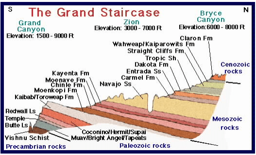
The Grand Canyon is at the far left and the Virgin River canyon in Zion National Park is in the middle. The regional tilt to the northeast is the main reason the Grand Canyon is deeper than upstream canyons. The Kaibab Limestone is about 5000′ above sea level in western Grand Canyon (it forms the rim) and about 20,000′ below sea level in northeastern Utah. The Wingate Sandstone that forms the Mule Ear is equivalent in age to the Moenave Fm, the Bluff Sandstone that forms the bluffs around Bluff is age equivalent to the Entrada Ss, and the Cedar Mesa Sandstone that underlies Cedar Mesa is age equivalent to the Kaibab/Toroweap Fm. All of the Mesozoic and Cenozoic rock layers have been eroded from above the Mule Ear Diatreme and Cedar Mesa. Illustration by Carmen Winn, who made this presentation at a symposium celebrating the 100th anniversary of Grand Canyon National Park in 2019. Wayne Ranney, a former Museum of Northern Arizona geologist and author of “Carving Grand Canyon” and a San Juan boater also made presentation at this symposium.
Dating of erosional surfaces confirms that erosion progressed upstream—incision began about six million years ago in the Grand Canyon and Little Colorado areas, about three million years ago in Canyonlands, and 1.3 million years ago in the Bluff area. There are San Juan River gravels on top of the Bluff Sandstone on both sides of the Bluff valley, so the river was meandering in a wide valley east of the Monument Upwarp at this time. Due to the much higher elevation of Cedar Mesa, incision probably began in the Goosenecks area about the same time as in Canyonlands.
Luna Leopold, son of Aldo Leopold (a famous environmental writer in the early 20th century), is considered to be the founder of modern surface water hydrology. In the late 1950s, he completed a study of the Colorado River drainage and determined that the data used by USBR (1910-1920) was for a period of unusually high discharge, and that if the data for the 1920-1950 period (including the Dust Bowl drought of the 1930s) was included, there wasn’t enough water to fill both Lake Mead and Lake Powell over the long term. Obviously, his report was ignored. Now, they’re both less than half full. He helped form the Water Resources Division of the USGS and today you can go on their website to obtain the current and historical discharge and chemistry of nearly every river in the US. For the San Juan, go to https://waterdata.usgs.gov/ut/nwis/uv?site_no=09379500.
My wife, Cynthia Appel, also a San Juan River guide (she used to run all-women trips), while working as a USGS hydrologist, calibrated and repaired the Lees Ferry and Grand Canyon gauges and was one of the authors of the Groundwater Atlas of the US.
Leopold published “A View of the River,” which has a chapter on meanders. About 80% of the length of a river is characterized by meanders. They allow flowing water to dissipate energy, they form in their own gravels in wide valleys, and they occur in low gradient reaches. They migrate downstream and when they encounter resistance, they bunch up and form goosenecks. When goosenecks are “cut off,” they form oxbow lakes. All of these are destroyed by floods and are rarely preserved by deep incision. If an incised gooseneck is cut off, it’s called a rincon. There are two rincons on the San Juan below Sand Island (Miles 12 and 18). On average, the amplitude of meanders and goosenecks is equal to their wavelength, and these are about eleven times the river width. Today, the average width of the rivers in the Colorado river drainage is about 20% of the width predicted by the average wavelength. Although it’s difficult to compare width to discharge, velocity increases at an exponential rate compared to volume and width is a proxy for volume, so the discharges that created the deeply incised goosenecks we view today were several orders of magnitude greater than the current flows.
Another piece of evidence that supports this need for huge floods is the depth of gravel above bedrock and the size of large boulders located in and perched on this gravel. The largest known flood in the Grand Canyon was estimated to be about a million cubic feet per second, caused by failure of a lava dam near Lava Falls about 165,000 years ago. This flood deposited fifteen-foot diameter boulders on benches above the river. Also, the average depth of river gravel above bedrock is about seventy feet, and floods of at least this magnitude would be required to entrain a gravel column of this depth in order to cause further incision.
Glacial outburst floods are the best explanation for floods of this magnitude, the debris from which has been found worldwide (such as in Scablands National Park in Washington state). Every river in the Colorado drainage has at least one large, deeply incised gooseneck near its source, after which smaller incised goosenecks occur as the flood dissipates, and then they slowly grow larger as tributaries add more discharge. The northern hemisphere entered the current ice age about two and half million years ago and since then there have been about thirty-five glacial advance/retreat cycles. Glacial melting and outburst floods during retreat cycles would have provided the massive amounts of water necessary to carry away thousands of cubic miles of sediment (worldwide), cause deep incision of the canyons of the Colorado drainage, and cause dramatic fluctuations in sea levels, as shown below:
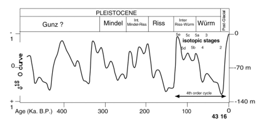
Note that sea level generally rises much faster than it declines, suggesting more rapid glacial retreat than advance and high flooding rates.
In summary, the deeply incised goosenecks of the San Juan were located on the upstream side of the Monument Upwarp after the river had filled the basin to the east and begun to overflow, causing meanders to bunch up and form goosenecks. These rock layers were thousands of feet above the current surface and are now in the Gulf of California. They were incised within the past few million years, and rapid incision was caused by glacial outburst flooding every spring in about thirty-five 10,000 year periods of rapid glacial retreat during this period.
Many San Juan River-running geologists contributed to this conclusion. If you’ve read this far, thanks!

Wow! What a tale and history.
LikeLike
Great article. thanks.
LikeLike
I am so glad that you wrote this article. Very nice to see all that history and geology in print. Looking forward to more stories from Peter Winn.
LikeLike